
What is going on with our seagrass?
- Betty Staugler — ASK YOUR SEA GRANT AGENT
- Feb 6, 2020
- 0
For the last several years, many anglers have expressed concern for the health of area seagrasses — and in many regards, rightly so. When seagrasses are thriving, that’s good news for the entire ecosystem. When they’re not, it’s a problem.
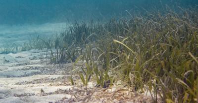
Seagrasses are structured habitats that support a diverse array of species, including economically valuable fishes and invertebrates. Additionally, seagrasses reduce shoreline erosion, oxygenate the water, capture carbon, trap sediments and improve water clarity. So, let’s face it, they’re pretty important! In fact, Florida’s roughly 2.2 million acres of seagrass is estimated to provide more than $20 billion in ecosystem services annually.
Because they are important, we want to maintain them. There are a number of ways seagrasses can be negatively impacted. As nutrient levels in coastal environments change so do the plants species. All plants require light, water and nutrients to grow.
Studies have shown that seagrasses generally dominate in waters with low nutrients and high light availability. When nutrient levels increase, microscopic algae are able to quickly grow, reducing the available light for rooted seagrasses below. Macroalgae (also called drift algae or rolling moss when red or seaweed when green) also tend to dominate where there is less light and more nutrients.
Other negative influences on seagrasses include dredge and fill activities, dock construction, trampling, anchoring, propeller damage and boat grounding. We know from previous studies that more than 50 percent of Charlotte County’s seagrass beds have some degree of propeller damage.
Seagrasses in Charlotte Harbor are monitored in two ways. Since 1982, the Southwest Florida Water Management District has conducted aerial surveys to determine seagrass acreage within Charlotte Harbor. This is accomplished by taking photographs from an airplane flying at a known elevation, and then identifying regions of seagrass coverage in each image. In this way, researchers can estimate seagrass resources across a very large area in a short amount of time.
New aerial photos were just taken in December of 2019. The aerial surveys to date have not shown any huge trends in seagrass acreage. But these surveys, as Capt. Van Hubbard pointed out in his Jan. 23 WaterLine column, have limitations.
In contrast, a monitoring program conducted by the FDEP Charlotte Harbor Aquatic Preserves describes both where seagrasses grow, and how much seagrass is there. Fifty, permanent underwater transects have been monitored annually in Charlotte Harbor since 1999. Think of a transect as a road with between five and 15 locations spaced along its length.
Each year, staff from the CHAP return to these precise locations — several hundred throughout Charlotte Harbor, Gasparilla Sound, Lemon Bay, and elsewhere — by getting in the water, with dive masks near the bottom, to estimate how much seagrass is present. The CHAP conducts their monitoring once a year in the late summer to early fall, when seagrasses are at their peak abundance for the year.
Their data has shown some changes along the deep edge of the seagrass bed, and they have also documented an increase in macroalgae in several locations. Transect monitoring also has limitations, in that only a small area can reasonably be surveyed.
Macroalgae typically has a competitive advantage in the winter and peaks in the spring. So, while macroalgae is showing up in the CHAP data, we are not capturing it at its peak. That is why I chose to start a new monitoring effort last year. This citizen science survey takes place in April (at peak macroalgal growth) and July (when healthy seagrass should take over).
In 2019, trained volunteers surveyed 26 sites in upper Charlotte Harbor. We use methods similar to the CHAP, but we do much shorter transects. However, we also collect considerably more macroalgae information. In April, volunteers documented a large macroalgae bloom on the east side of Charlotte Harbor. Through additional surveys and angler reports, we know this bloom is still occurring and has grown considerably.
Studies indicate that nitrogen is generally the nutrient that seems to control macroalgae growth rates throughout the year. However, phosphorus alone, or, at certain times of the year, both nitrogen and phosphorus together, may be important. To complicate this, different species of macroalgae can be limited by nitrogen or by phosphorus in the same estuary.
One of the biggest challenges when nutrient levels increase is identifying where the increase is coming from. Regular water monitoring programs cannot get to that detail without including some sophisticated and often costly sampling.
So now what? We can’t just sit back and watch the macroalgae grow. And we are not. In recent weeks, we’ve looped in experts at the University of Florida, who have offered to help us determine what nutrients are feeding this bloom. This type of testing is more sophisticated than we are able to do locally.
It’s worth noting that a well-respected algae scientist published a paper after the severe red tide bloom in 2005-06, describing a synergistic relationship between red tide and other algae species. As such, it’s possible the algae we are experiencing on the east side of Charlotte Harbor, and nutrients driving it, are a remnant of the severe 2017-19 red tide bloom (lingering decomposition).
However, we do not know that for certain, and don’t want to make assumptions. If the bloom is being driven from nutrients coming from the adjacent land, we need to know. Determining what nutrient sources are contributing to macroalgae growth will enable resource managers to implement appropriate corrective action.
In 2020, I will be expanding the volunteer monitoring to Lemon Bay. More on that to come, but if you have a boat, kayak, paddleboard, or floating bathtub and want to recruit some friends, I’ll be looking for several teams of three or four (mask, snorkel and fins are needed too).
Betty Staugler is the UF/IFAS Extension Charlotte County agent for the Florida Sea Grant Program. She is active in many areas relating to boating, fishing, and watershed/coastal living. Sea Grant supports research and education activities that help Florida’s shoreline communities, industries and citizens wisely use the state’s coastal and marine resources. Contact her at staugler@ufl.edu or 941-764-4346.
Betty Staugler is the UF/IFAS Extension Charlotte County agent for the Florida Sea Grant Program. She is active in many areas relating to boating, fishing, and watershed/coastal living. Sea Grant supports research and education activities that help Florida’s shoreline communities, industries and citizens wisely use the state’s coastal and marine resources. Contact her at staugler@ufl.edu or 941-764-4346.
- Jay Mastry - March 26, 2024
- Captains Corner, Gorta - March 23, 2024
- Dave Zalewski - March 12, 2024


